Tuesday, September 11, 2018

8/15 to 8/18/2018 - Twin Lakes (Sequoia National Park)


Walk away quietly in any direction and taste the freedom of the mountaineer. Camp out among the grass and [flora] of glacier meadows, in craggy garden nooks full of Nature's darlings. Climb the mountains and get their good tidings. Nature's peace will flow into you as sunshine flows into trees.

- John Muir 


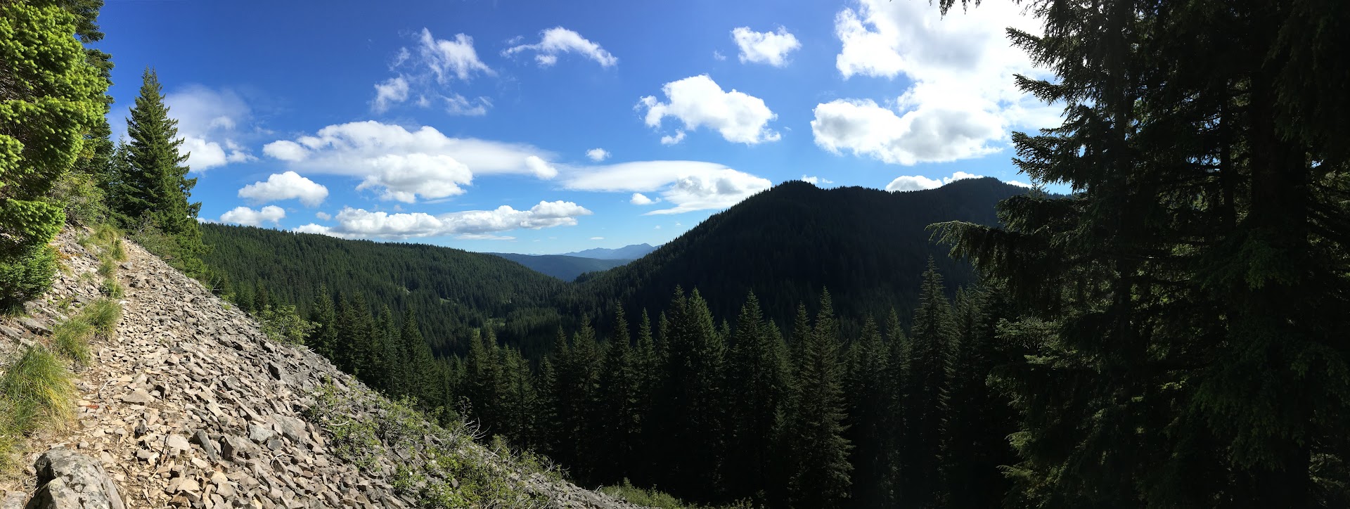
Opening shot - looking east toward the Great Western Divide (just beyond the horizon: Pacific Crest Trail/John Muir Trail, Mt. Whitney, et al). Click this LINK, then right click the image and select "open image in new tab" or "save image as" for full resolution panorama with labels.

Hike Stats

Depart 08:30 on Wednesday, Aug 15, 2018
Arrive 11:45 on Saturday, Aug 18, 2018
(4 days, 3 nights)

27.9 miles
6,173' elevation gain
11 hours, 17 minutes hiking
39 hours, 15 minutes total

Photos

LINK to all photos and videos (many)

Report

Kylie and I arrived at our car-camping site around 5:00pm, set up our shelter, and then snacked while sipping screw-top wine until hiker-midnight (approx 8:30 on this night). Our 2 campground neighbors were as follows: a mixed crowd of 7 backpackers, junior and weathered alike, with which we'd leapfrog on trail 3 times over the next 3 days; the other an endearingly boisterous band of 8+ car-camping buddies whose shenanigans included a rousing game of Mafia which Kylie and I found especially entertaining.

But it was the night before our 4-day hike, so we were grateful that all was quiet once the sun set on Big Meadow Campground. 

Sleep came, then we heard big animal steps - slow and kind of far away but towards the boys' camp. Then... scream-mooing? It was loud and continued off and on for a few minutes and we thought it might be the boys messing with each other - but we also heard large footsteps... Then we heard footsteps by our tarp followed by a loud, "MoooOOOooo."

They were cows. Two of them from who-knows-where, but they just wander around terrifying people for fun I guess.

Oh well. The next morning (Wednesday), Kylie and I were packed up and moving out earlier than either of our camp neighbors. By 8:00am we were driving the short way down the road to Big Meadow Trailhead. 


Falkor (our trusty new Subaru) and our full packs - each with 4 days of food and 1 liter of water.
Now on foot and moving at just 2.5 MPH, Kylie and I immediately observed the differences in Sierra Nevada vs. Oregon hiking. The trees were fewer in number but larger in diameter and more red in the trunk. Where bushes, brambles, and saplings dominate the lush, green understory in Oregon, here at 8,000+ feet, it is sparse of vegetation and mostly sandy.

For Kylie, hiking in the Sierra represented a homecoming - a tribute to her younger days spent backpacking in these same forests with her family. Indeed, the very next day would bring us to Silliman Pass over which her Father and Uncle passed years before on one of their own backcountry adventures. 


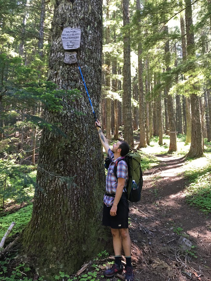
Jennie Lakes Wilderness boundary: a literal act of Congress.
Our first 7 miles hiking was nearly all uphill, taking us up the slopes of Shell Mountain, along the perimeter of Poison Meadow, and then finally up the aptly-named Poop Out Pass before reaching the junction for Jennie Lake. Here, we found a picturesque lakeside oasis where we'd loosen our shoes and take a lunch break along the scenic shore.

In two days time, headed back for the trailhead, we'd arrive here again looking for a place to camp. Today, however, required another 5.5 miles of effort to take us all the way to Twin Lakes.


Not so smelly yet.
Feeling recharged, our shoes were again donned and put to work. A short jaunt brought us to the boundary of Sequoia National Park. Though I imagine many-a-hiker pass by these humble signs with little adoration or notice, I always feel compelled to stop and revel in the importance they portend: that is, a Congressionally-protected wilderness experience. I feel that John Muir and others of his persuasion would be proud enough.

From here we faced a 4-mile, 1,000' descent-then-climb to reach Twin Lakes at 9,419'.


Thanks, America.
At 6:00pm we lumbered into camp, covering 12+ miles and 3,600' gain for the day. After much pacing and deliberation, we set up our tarp and bug-net in a somewhat secluded, though still proximate, flat spot sheltered by a large boulder. There were 15+ people camped within 100' of us and perhaps 30 more dispersed around the rest of the lake but all were hidden from sight behind our large boulder and downed tree. Here we would stay for 2 nights, affording us a base camp from which we could explore the surrounding area carrying minimal gear.


Check out the backcountry toilet! It was great except for the bees.
The next day (Thursday), we slept in before beginning our day-hike up to Silliman Pass around 11:00am. At 10,170' along the Kings-Kaweah Divide, the pass and nearby Twin Peaks (10,479') provide sweeping, unobstructed views of the vast Sierra Nevada.

Most geographically notable of all the sights is the Great Western Divide to the east. Besides housing numerous 13,000' peaks, it separates three major Central California watersheds (Kaweah, Kern, and Kings rivers) and serves as a western boundary of the hallowed High Sierra. Just beyond lie the Pacific Crest and John Muir trails in addition to the tallest mountain in the contiguous US.

Click this LINK, then right click the image and select "open image in new tab" or "save image as" for full resolution panorama with labels.


Kings Canyon in background, cool hat in foreground.

Mt. Silliman (11,188') to the south, across Silliman Pass from Twin Peaks.
Even with ample time to appreciate the views at the top, we were back in camp by 3:00pm. Dinner was once again enjoyed lakeside. 


Alpenglow sunset over (big) Twin Lake.

Camp, nights 1 and 2.
The morning of day 3 (Friday) marked the beginning of our return journey. Luckily, our itinerary included spending 2 days to tackle the 12 miles back to the car - we were accordingly pleased with ourselves for having handled that distance on our first day.

Goodbye, Twin Lakes.
The day of hiking was hot, a direct result of our casual 11:00am start. No matter, there were only 6 miles to span on this day. 


Searching for shade.


A huge natural drainage along the trail; I would love to see it flowing in the Spring.
At 2:00pm we approached Jennie Lake for the second time and already there were a handful of groups set up around the lake. One such cohort, a father with 2 kids, was camped much too close to the shores of "The Peninsula" despite the clearly-posted rules and signs prohibiting it.


No camping on the "The Peninsula"...

...unless you reallllly want to.
For shame! Nevertheless and again after much pacing and deliberation, Kylie and I enjoyed our spacious and legal campsite upon a small rise well outside the 100' restoration area. More groups trickled in throughout the evening; after all, it was Friday.

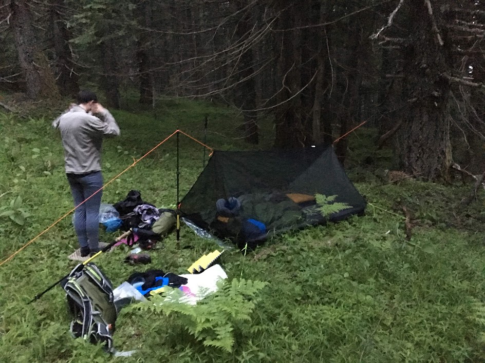
As the sun fell, Kylie suggested that we forgo the tarp and instead set up only the bug-net, trusting that the weather would continue to provide. We were appropriately rewarded as countless stars above served as our gentle night-light, urging us to stay awake. We reluctantly resigned to sleep on this, our last night in the wilderness.

Camp, night 3.
The next morning, our last cups of hot chocolate were relished as we packed up for the last time. We were on trail by 8:00am with our sights set on showers and snacks. This 4th and final day of our trip held only 7 downhill miles between us and Falkor. From there, we'd drive to the family cabin in nearby Kings Canyon National Park.

The remaining section of trail now felt familiar, having traversed it just 3 mornings prior. We hiked swiftly but stopped freely to enjoy the small details: a pine cone with brilliant pink insides, a huge snag overhanging the trail.

The scale is immeasurable.
Now a weekend day, we passed many groups who were headed out with varying levels of preparedness; Kylie and I were happy to be on the other end of our trip. 


Hooray!


Wednesday, July 4, 2018

6/29 to 7/1/2018 - Salmon-Huckleberry Wilderness Loop


Counter-clockwise loop.

Stats

Depart 17:30 on Friday, 6/29
Arrive 09:16 on Sunday, 7/1

27.7 miles (plus 3.1 other miles)
7,200' elevation gain
12 hours, 40 minutes hiking
39 hours, 48 minutes total
2.43 hiking mph

1 owl, 3 salamanders, many bees, many birds (heard), 1 tick

Photos

Link to all photos and videos (many many)

Report

My BFF and I were looking at the Loowit Trail for last weekend, but we weren't sure about the snow conditions or weather. So we went with something much closer and very different: a loop through the Salmon-Huckleberry Wilderness along Eagle Creek and the ridges that connect Tumala Mtn, Sheepshead Rock, and Wildcat Mtn.

We drove out after work and got only slightly lost near The Douglas Trailhead (called Wildcat Mtn Trailhead in Google). The directions given in the Field Guide are correct, I just misinterpreted them. Roads are paved the whole way until the parking lot.

After our brief detour, we arrived at the TH around 17:20 and were pleased to see only 2 other cars.

The ultimate trailhead vehicle.
We came upon one of their humans 1/4 mile in; he was headed back towards the TH. This was the last person we'd see for 39 hours until we were back within 1/4 mile of our car -- true wilderness solitude!

With only 4 hours of daylight, it was convenient that day 1 was all downhill, losing over 2,000' on the way down to Eagle Creek. The trail was great except for when it was overgrown by salmon berries and thorny bushes.

BFF in the bush -- the thorny ones bite.
Along our entire route, we encountered 20-30 patches of overgrown trail, each ranging from 10-100' in length. Perhaps 25% of these patches had thorny bushes, making shorts a questionable choice. My pants-clad hiking partner certainly fared better than I.

We had dinner at a small creek where it crossed the trail and then made camp a mile further down, well uphill and away from the creek. Bug pressure was minimal and the weather was clear and calm so we chose to forgo both our tarp and bug shelter. It was our first time "cowboy" camping and it was truly an amazing experience. As dusk faded, we were able to hear and then see an owl fly quite near us (video of hoots in album). 6.5 miles on the day.

Day 2 required 16+ miles and 5,000' gain. We broke camp and were hiking by 9am, a little late for the long day ahead. The forest here along Eagle Creek holds a fantastic mix of old and new growth. Isolation from civilization was noticeable and the the occasional airplane served as the only reminder of our proximity.

We meandered along, stopping to scope out the established campsites (of which there were 3) and to take videos of each other.


Breakfast spot, day 2.

Old life supports new.


Beautiful.
The Eagle Creek Ford was a mostly dry, easy one. Although steep, the Eagle Creek Cutoff Trail is wide and clear, climbing 2,000' up to gain the pass below Tumala Mtn.

Why so high? At least losers hadn't yet put bullet holes in them.

At 16:30 and mile 11 for the day, we paused for dinner at a tremendous southerly vista -- Tumala meadow and lakes below -- created by an impressive rockfall. Confident of having a water source at camp that night, we consumed all of our water with our dinners.

Dinner with a view.

Our relaxing 9am start and leisurely pace along Eagle Creek earlier in the day got us into camp just as the sun was setting, not affording us enough time to search for the proper Coffman Camp and associated spring. So again we turned off trail and found a stealthy flat spot free of bushes under and large tree and canopy. We went to bed thirsty and hungry, afraid to eat any of our candy bars lest it dry out our mouths further.

Having been treated so well by the weather the night before, we decided to only set up the bug shelter and again go tarp-less. We ignorantly dismissed the low, dense fog around us and laid down for the awful night ahead.

Camp, night 2.

Drops began falling on our faces around 22:00, so I suggested simply pulling the tarp inside our bugnet and laying it over the top of us; we figured the weather would be temporary and therefore lazily chose to forego getting out and properly setting up the shelter above us (we later posited that this "rain" was likely just water condensing out of the fog onto the tree leaves above us and then raining down onto us. i.e. if we would've camped in the open, we likely would've stayed dry[er]).

The clear drawback of this plan became evident as condensation began soaking us from the inside, under the tarp. In addition, puddles began forming around us inside the bug shelter soaking the feet and sides of our bags. Feeling defeated, we quietly settled in for a night of wet tossing and turning with little to no sleep. The lesson we learned was clear: bite the bullet and set up your shelter properly at the first hint of weather. 16.5 miles and a monkey butt load of climbing on the day.

We arose with the sun, thankful to be thru the night. Save for the long undies and fleece shirt I was wearing, everything else was wet: hiking clothes, shoes, backpack, beanie, etc... Packing up was a cold and somber affair.

Luckily, we had only 4.7 miles back to the car on this day, our third and final of what had been a generally enjoyable trip. Coffman Camp and its spring was just 1/2 mile down the trail from whence we camped and so we replenished our bottles and continued on. Our sorrows began melting away once we were covering ground; the weather was mild if not a bit wet and the trail was clear of overgrowth. 

Happy hikers.
By 09:00 we had reached the gravel pit and knew we had made it, our feeling of accomplishment duly earned.