Stats
19.4 miles (plus 1 other miles to Jefferson Park campsite)
4,152' elevation gain
7.75 hours hiking
2.63 hiking mph
Photos
Link to all photos from day 13.
Journal Entry
italics = original journal text
regular = added during transcription
New month, new day.
Hiked in[to] Jefferson Park today after 19 miles & 4,100' elev gain, R achilles sore all day. This was only somewhat unsettling. I've dealt with a sore achilles tendon before, but most times it would get better throughout the hiking day. This time, it was sore from about mile 3 through the end of the day. Was planning on stopping @ Breitenbush CG (5 miles further), but my sore ankle and the setting thought otherwise. And boy am I glad. This huge meadow lies just north of Mt. Jefferson. A few modest-size lakes are near the PCT. I'm staying about 100 yds east of Russell Lake at a lesser used spot among the patches of trees. The view of Jefferson is amazing. Reminds me Mt. Hood up close.
The ranger I spoke to below essentially told me that I could camp wherever I wanted; he and his partner weren't going to be patrolling that area for permits that night. However, I didn't want to set a bad example by displaying to others I was breaking the rules.
I first found a spot right on the lake, but only reserved designated sites are allowed w/in 250'. I took the opportunity to dry my ground cloth, clothes (after a swim), and quilt while basking in the sun. I then packed up and hiked ~1/2 mile to the far side of the lake & a bit beyond. Favorite campsite so far.
Not only was this campsite aligned with the rules, it was more secluded and had better views of the mountain.
Ran into a ranger rt after Russell Creek (not related to lake) who was out searching for a lost teenaged hiker (actually 21 years old). The helicopters and planes have been incessant throughout the day, searching from the summit to Jefferson Park.
I learned from the ranger that Riley Zickel was the missing hiker. He departed on an overnight trip the previous Wednesday (6 days prior) and had not been seen since.
After crossing the raging Russell Crk, this news was a stark reminder of nature's unyielding force. I hope he's alive & found.
Russell creek was the most treacherous crossing I encountered on my trip. While not comparable in danger to early-season crossings in the Sierra Nevada range, it presented a challenge that was not trivial. I spent 30 minutes walking upstream and back, searching for the safest spot to cross. Eventually, I made the crossing near where the trail intersects the creek.
Started Red Rising (audiobook) today & I think I'll like it. Already on Ch. 13(?). The one where Daryl (Daro?) is at the carver.
Headed towards Mt. Jefferson (10,497').
More unique trail.
More unique trail, this one through a colorful meadow.
Views opening up, Mt. Jefferson getting closer.
Three Fingered Jack (7,841') 10 miles to the south.
Looking up towards the summit of Mt. Jefferson from Milk creek along the western slopes.
Final switchback before descending to Russell creek.
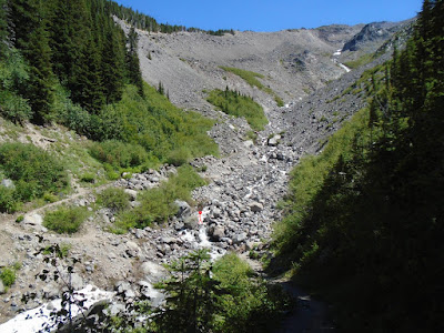
Red stick figure is my size and is shown for scale.
First picture from Jefferson Park.
First campsite, just drying everything out.
Just like being at the laundromat; except way better and nothing like the laundromat.
Having second dinner, Jefferson Park.
#wildernessculture or something.
Sunset from camp in Jefferson Park.


No comments:
Post a Comment